|
Getting your Trinity Audio player ready...
|
Spaghetti plots. Cones of uncertainties. Rapid intensification.
Hurricane terms can be difficult to understand and downright confusing, while social media is full of models that show different paths a hurricane might take. It all makes it difficult to determine just how much danger we face when a major storm approaches.
Amid an Atlantic hurricane season that’s predicted to be particularly active, starting with Hurricane Beryl bearing down on the Gulf of Mexico, we asked experts to share how they track storms and what to look for.
How to track a hurricane
If you haven’t already, bookmark Hurricanes.gov. Make a habit of checking the website at least once a day during the Atlantic hurricane season, which runs from June 1 to Nov. 30.
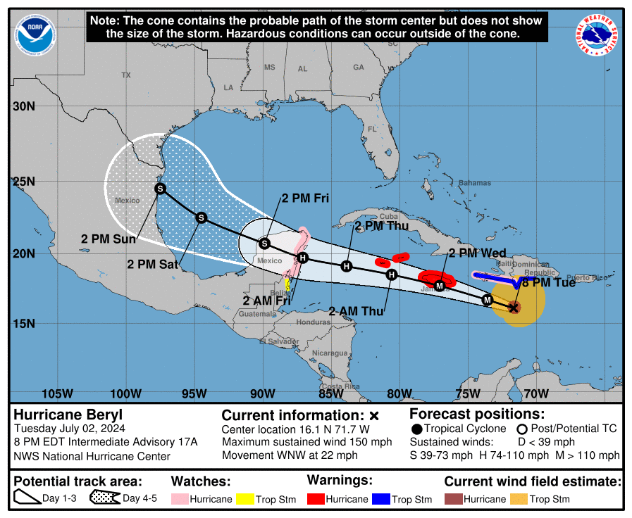
The National Hurricane Center keeps an eye on the Atlantic and Pacific oceans for disturbances that could develop into tropical storms. Once a storm forms, the agency issues a map showing its probable path.
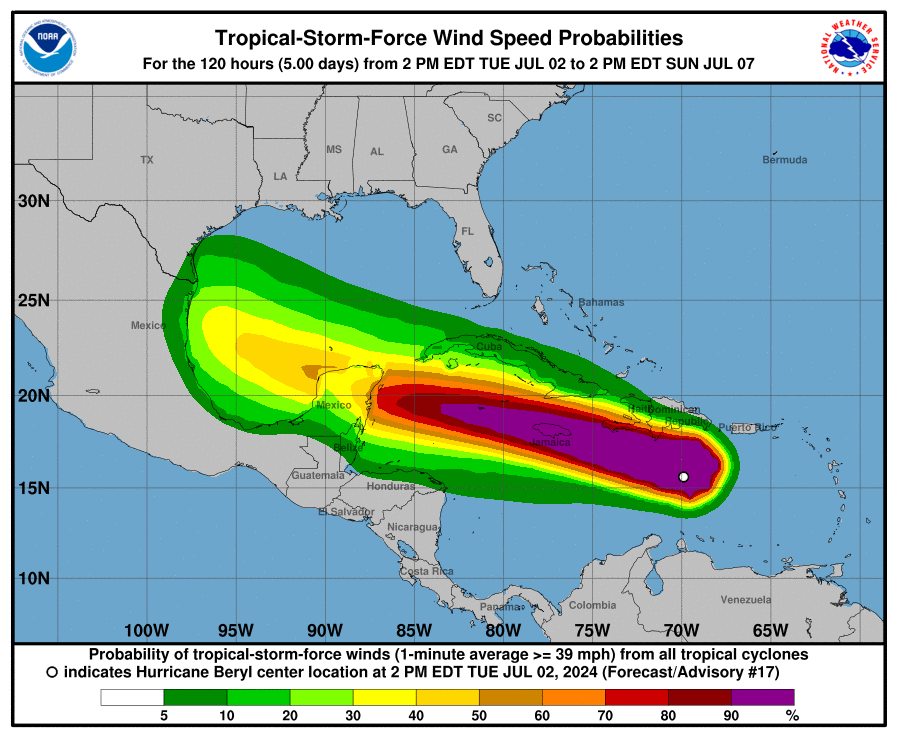
Expect the projected path of the storm, also referred to as the “cone of uncertainty,” to change as meteorologists learn more about the storm. The seven-day tropical weather outlook also has useful information on the chances of a storm becoming more destructive.
“It takes a little bit of practice, but just looking over the page and checking out the different products will give you some familiarity,” said Dan Reilly, warning coordination meteorologist at the National Weather Service in Houston.
If a storm looks to affect the Texas Gulf Coast, Reilly said his office will pump out crucial information like how much rain to expect, the anticipated amount of flooding and what the storm surge might look like.
Other go-to websites for Matt Lanza, a meteorologist at Space City Weather, are TropicalTidbits.com and Weathernerds.org.
What to look for
The “cone of uncertainty” is a tool forecasters use to communicate the probable path and impact of a storm. The National Weather Service’s cones show a line with the predicted track of the storm, along with an outer bubble that describes where the storm might travel.

Forecasters also use spaghetti models to show different paths a storm may take. Spaghetti models have their drawbacks, however. One such downside is that the potential impact of a storm isn’t clear, giving people a false sense of confidence about the storm’s severity.
When looking at spaghetti models, don’t focus on the outliers. Focus instead on the cluster of lines.
“If there are 50 different lines and there’s two going to Texas and the rest are going to Mexico, that’s generally a good indication that this is probably going to go to Mexico,” Lanza said.
Be cautious about what you read on social media. Lanza said much of the information about storms on the internet is incorrect.
When to start worrying
It’s time to start worrying if you live within the cone and the majority of spaghetti strands start to point in your direction. Be sure to check the trusted hurricane websites several times a day for the most up-to-date information.
You’ll likely have four to five days worth of warnings before a storm hits to gauge whether to evacuate or ride things out, Lanza said. Make a game plan ahead of time for where to go and possible routes to get there in the event of an evacuation.

related to hurricanes
10 things Houstonians need to know as the region enters the 2024 hurricane season
by Angelica Perez / Staff Writer
Also be sure to make a go-bag full of nonperishable food, water, extra medicine, cash and other essential items.
Lastly, consider getting flood insurance. Notably, renters insurance doesn’t pay for flood damage.
What to watch for with Hurricane Beryl
After bringing heavy rain and destruction to several Caribbean islands, Hurricane Beryl was downgraded Tuesday from a Category 5, the most severe storm classification, to a Category 4. The hurricane is expected to continue moving west and impact portions of Jamaica and the Cayman Islands on Wednesday.
Lanza said Beryl is predicted to be a Category 1 by the time it reaches land in Central America near the Yucatan Peninsula and Belize later this week.

Even if the hurricane defied the odds, stayed strong and began moving north, the chances of the storm intensifying in the Gulf of Mexico as rapidly as it did in the Atlantic are slim because of colder temperatures in the gulf, Lanza said.
Lanza predicts Beryl will bring rain to the Houston region sometime this weekend or early next week, but how much remains up in the air.
“There are still a lot of things we have to watch in the next two days before we can really get an idea as to how this may or may not impact us,” Lanza said.
What Beryl tells us about hurricane seasons
Beryl, the earliest Category 5 hurricane on record in the Atlantic Ocean, exemplifies why Lanza is concerned about this hurricane season.
Water temperatures in the Atlantic are hotter than what they normally are at the peak of the season in September, Lanza said, paving the way for storms to rapidly develop and intensify as Beryl did.
“Even marginal systems are going to be able to kind of feast on these (warm water temperatures),” Lanza said. “Maybe instead of a weak tropical storm, we have a moderate tropical storm now. Or instead of a tropical depression we have a tropical storm. Storms that were borderline will now be able to cross over and become named storms.”
Coupled with a La Niña climate pattern in the Pacific Ocean, the warm temperatures in the Atlantic could make for an active season, as forecasters predict.
“I hope Beryl ends up being the warning sign for everyone that this isn’t hype. This is the real deal,” Lanza said. “It would be extremely unlikely for it to not be a busy season. That doesn’t mean there’s going to be a bunch of systems that hit land. I hope that’s not going to be the case. But you can’t rule it out.”


